The Amazing Ancients
A good site for ancient ruins:
muslimdotorg
a little (nay, a gold mine) on Nabateans:
The Nabateans
Click on what interests you, e.g. Petra
a more comprehensive index of the same site:
Subject Index to Nabataea.net
nabataea.net regards the ruins of Petra, Madaine Salih and Ubar as those of a single civilisation or people. These could easily be slightly different peoples of Ashabul Hijr, Thamud and Aad. However, the above site is a mine of information and pictures.
google search Nabateans
Petra:
A walk around Petra – with enlargeable thumbnails
The complete Petra
Mansour Mousher’s phto galleries – very comprehensive
world66-petra
trekearth
murrayc_2001 – Petra
Petra by Satellite
Petra – brown.edu
brown.edu petra pics index
2002-excavations
Petra – angus
Gallery – Petra 3
studium biblicum franciscum
The complete Petra links
comprehensive Petra pictures (334)
nationalgeographic.com
the small & dangerous shiq
Al Beidha: Little Petra, shiq & all
upenn.edu
kinghussein.gov.jo/tourism6d
ce.eng.usf.edu-forgotten wonder
galenfrysinger.com/petra
Maps & pictures of Petra:
http://www.petranationalfoundation.org/images/home.treasury.large.jpg
http://img.photobucket.com/albums/v245/LilPuto/Petra/petra_map.jpg
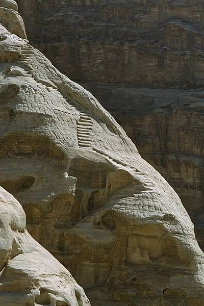
http://img.photobucket.com/albums/v245/LilPuto/Petra/NabataeanStairs.jpg
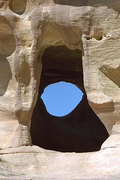
http://img.photobucket.com/albums/v245/LilPuto/Petra/EyeWall.jpg
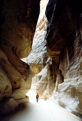
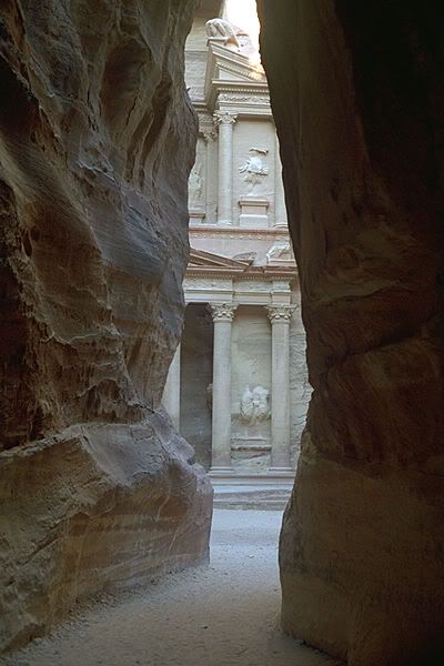
http://img.photobucket.com/albums/v245/LilPuto/Petra/siq.jpg
http://img.photobucket.com/albums/v245/LilPuto/Petra/SiqKhazneh.jpg
http://img.photobucket.com/albums/v245/LilPuto/Petra/Khazneh.jpg
http://img.photobucket.com/albums/v245/LilPuto/Petra/KhaznehAbove.jpg
http://img.photobucket.com/albums/v245/LilPuto/Petra/monestary.jpg
http://img.photobucket.com/albums/v245/LilPuto/Petra/RoyalTombs.jpg
http://img.photobucket.com/albums/v245/LilPuto/Petra/RoyalTombsTop.jpg
http://img.photobucket.com/albums/v245/LilPuto/Petra/UrnTomb.jpg
http://img.photobucket.com/albums/v245/LilPuto/Petra/Sextius.jpg
http://img.photobucket.com/albums/v245/LilPuto/Petra/Petra07.jpg
http://img.photobucket.com/albums/v245/LilPuto/Petra/Petra05.jpg
http://img.photobucket.com/albums/v245/LilPuto/Petra/PalaceTomb.jpg
http://img.photobucket.com/albums/v245/LilPuto/Petra/GardenTomb.jpg


map of surroundings of Petra


Map of Central Petra

map of Petra
Here you can see a “picture map” of Petra. The Khazneh (the Treasury) is exactly in the middle, with the entrance to the right, still on the bottom of the map. The Obelisk Tomb and the Djinn blocks are marked.
The path continues through the Outer Siq towards the theatre, with the Urn Tomb and the Royal Tombs to the right, and the temples and the “Paved Road” in the centre of the ancient city. The “Monastery” is high up to the left.
The tombs lower to the left are the complex around “the tomb of Sextus Florentinus” and you can see the “High Place” between them and the Khazneh.
Warning : from the Obelisk Tomb to the Monastery is something around 8kms, more if you take in the High Place and/or the Royal Tombs and the Great Temple on the way!
This “guided visit” is the work of Jean Claude Golvin
Many influences are apparent in the architecture of Petra; Assyrian, Egyptian, Hellenistic and Roman. Most of the visible remains date from the Roman period, yet somehow bear a unique Nabataean stamp. It is mostly the rock-cut tombs which remain today, though freestanding temples built of stone, the Qasr Al-Bint Temple and the Temple of the Winged Lions can also be seen.

atlastours.net map
· 1 Djin Blocks
· 2 Obelisk Tomb
· 3 Al-Siq
· 4 The Treasury
· 5 Street of Facades
· 6 The Theater
· 7 Aneisho Tomb
· 8 Urn Tomb
· 9 Silk Tomb
· 10 Corinthian Tomb
· 11 Palace Tomb
· 12 Sextus Florentinus Tomb
· 13 House of Dorotheos
· 14 The Nymphaeum
· 15 Colonnaded Street
· 16 Byzantine Church
· 17 Winged Lion Temple
· 18 The Arched Gate
· 19 Qasr Al-Bint
actually, what has been termed as The Great Temple is missing on this map. It is larger than Qasr al-Bint
· 20 Unfinished Tomb
· 21 Al-Habees Museum
· 22 Petra Archeological Museum
· 23 Lion Triclinium
· 24 Al-Deir
· 25 Turkmanian Tomb
· 26 Conway Tower
· 27 Moghar Annassara
· 28 High Palace of Sacrifice
· 29 Lion Monument
· 30 Garden Temple Complex
· 31 Triclinium
· 32 Renaissance Tomb
· 33 Broken Pediment Tomb
· 34 Roman Soldier Tomb
· 35 Snake Monument
· 36 Crusader Fort
The Bab Al-Siq Area
As one makes one’s way through the gorge, on horseback or on foot, to the entrance of Al-Siq or narrow defile, the first monuments one sees are three massive Djin blocks. There are about 40 such monuments to be found in Petra. Their significance is as yet uncertain. They are generally thought to have been an early form of Nabataean tomb, though their proximity to running water may signify that they were related to the worship of water, bearer of fertility.
Opposite the Djin blocks are two monuments, the Obelisk Tomb and the Bab Al-Siq Triclinium, which stands below it. Although they are found in close proximity to one another, they appear to be unrelated, dating from various periods and standing on a slightly different axis. The Obelisk Tomb takes its name from the four Obelisks which decorate its upper storey.
The Obelisk was a common Nabataean funerary symbol and clearly demonstrates Egyptian influence. An inscription in both Greek and Nabataean to be found opposite it, refers to a family tomb built by Abdmank which may well be the Obelisk tomb itself.
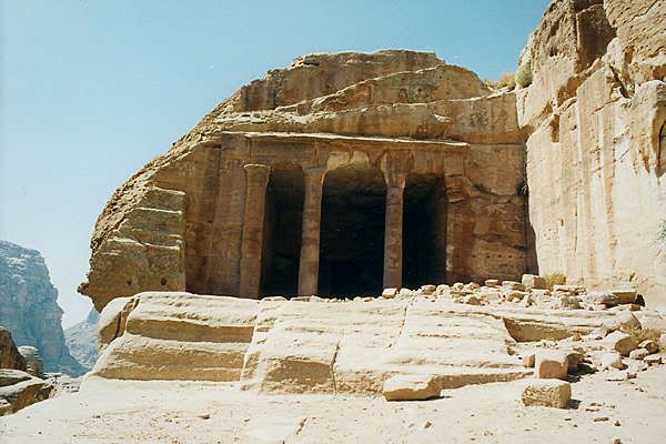
The Bab Al-Siq Triclinium, constructed at a later date and more classical in style, is the first of approximately 100 similar monuments to be found throughout the site. These were rock-carved rooms with benches running around three sides of their interior, situated near tombs, so as to act as dining rooms for the funerary banquets which appear to have been an essential ritual in burying and commemorating the dead.
There are many large tombs in the Outer Siq, some of them bearing obvious traces of earthquake damage. The Tomb of the 17 Graves clearly demonstrates how the graves were cut into the rock floor. Also noteworthy are the five small commemorative Obelisks and two Nabataean inscriptions carved onto the walls.
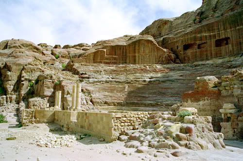
As the Outer Siq opens out, the Street of Facades becomes visible. Whole streets, 4 rows, one above the other, of Assyrian type monuments with double bands of crow-step decoration run along the cliff face. It isn’t known whether these served as houses or tombs but they appear to be of an early date.
Beyond the Street of Facades lies the Theater, which was constructed in the early 1st century AD by Nabataeans and enlarged and improved by the Romans shortly after their annexation of the Kingdom in 106 AD. This they did by ruthlessly gouging away a street of houses or tombs in order to extend the rear of the auditorium, which could then accommodate 3000 people.
This also improved the acoustics of the theater and supported a drain, which took the run-off water around the sides of the theater. The standard Roman-design theater today lies open to the Outer Siq, but would originally have been enclosed by a wall and completely cut off from the street.
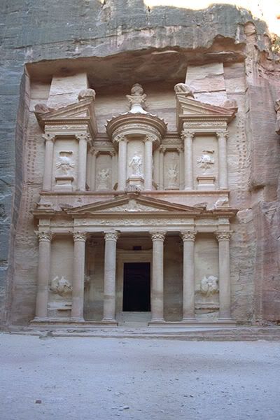
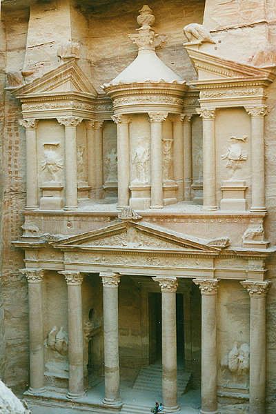
The Treasury
“A beam of stronger light breaks in at the close of the dark perspective, and opens to view, half seen at first through the tall narrow opening, columns, statues, and cornices of a light and finished taste, as if fresh from the chisel, without the tints or weather stains of age, and executed in a stone of a pale rose color, which was warmed at the moment we came in sight of them with full light of the morning sun”.
Little has changed the Treasury since the Hon. Charles Irby and Mr. James Mangles, commanders in the British Royal Navy, described their first sight of it in 1818. “We do not know with what to compare this scene”, they added; “perhaps there is nothing in the world that resembles it”.
It is justly the most famous monument in Petra, perhaps from the impact of the first glimpse of that luminous strip at the end of the towering penumbra of the Siq.
Suddenly we emerge into a natural courtyard face to face with the glowing perfection of the Treasury. Its elaborately carved facade is alive with a cast of Nabataean deities and mythological characters – equestrian figures of the Dioscuri (Castor and Pollux) whose role in the Greek myths was to guide the souls of the dead to the Elysian Fields; dancing Amazons wielding axes; winged Victories; Medusa heads; eagles and various mythical creatures. All are funerary symbols.
At the center of the tholos – the round section between the broken pediment at the top of the facade – is the eroded relief figure of a goddess holding a cornucopia in her left arm. This has been identified as Al-Uzza, the great goddess of Petra, who was commonly assimilated with the Greek Aphrodite, goddess of love; here she includes the attributes of Tyche, the Greek goddess of fortune, and of Isis, the supreme goddess of the Egyptian pantheon who, as the wife of Osiris, also presided over the underworld and the spirits of the dead.
Though all the figures are eroded, the flowers, leaves and fruits on the friezes, pediment and capitals still look, miraculously, almost as crisp as the day they were carved.
In Arabic the Treasury is called El-Khazneh, or Khaznet Far’oun, Pharaoh’s Treasury, from an ancient myth that treasure had been concealed here by a powerful black magician, popularly identified with a wicked and fabulously wealthy Pharaoh: who else but he who proceeded the Pharaoh who drove prophet Moses (pbuh) and his followers out of Egypt and chased them here to Petra?! At this point, it seems, the Pharonic treasure had become an impediment.
Not this monument alone, but the whole of Petra, was believed to be a storehouse of Pharaoh’s wealth, deposited here by deep magic; but this, the most sumptuous monument, must surely have housed his greatest riches. The urn at the top was deemed the most likely repository, and every Bedouin who owned a gun would take a shot at it as he passed, in the vivid hope that if he hit the right spot all the treasures of Pharaoh would cascade down upon him. The result is a sadly battered urn and not a whiff of treasure.
So ferociously did the Bedouin of the 19th century believe in the existence of treasure, and in magical powers, that they suspected all western travelers of being magicians who had come to spirit away the hidden wealth out of reach of themselves, the rightful heirs and owners.
“Nor are they satisfied with watching the stranger’s steps”, as Burckhardt wrote in 1812: “They believe that it is sufficient for a true magician to have seen and observed the spot where the treasures are bidden… in order to be able afterwards, at his ease, to command the guardian of the treasure to set the whole before him”.
Small wonder that those early visitors were given such an unwelcoming reception.
The Treasury’s original purpose remains elusive – except that it was not a Treasury. Some scholars believe it was a royal tomb, with the king’s burial place in the small chamber at the back; others, a temple, pointing to its temple-like facade and the lack of burial holes – for them the rear chamber was the sanctuary, complete with ritual ablution basin.
Yet others suggest it was a memorial mausoleum, perhaps for the cult of the deified Obodas I. The funerary symbolism of the carvings on the facade certainly points to some association with the dead.
Yet another view is that this was a library. See nabatea.net for this.
The date of the Treasury is also unclear, and has to be assessed on stylistic grounds, providing yet more theories. It is tempting to suppose that its ornate carving points to a later period, but Petra has proved a graveyard for such neat solutions.
Some scholars suggest around 25 AD, under Aretas IV who initiated much construction and urban planning, and who may have brought craftsmen from Alexandria. The consensus now favors the reign of Aretas III Philhellene (86-62 BC), a time of great expansion and exposure to Hellenistic ideas.
Whenever it was carved, and for whichever Nabataean king, Hellenistic ideas were here brilliantly transformed into a design that kept a distinctively Nabataean flavor. And whatever its purpose, the sitting of the Treasury at the end of the forbidding twilight of Al-Siq was clearly designed to strike wonder into all who entered the Nabataean capital.
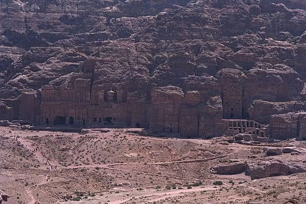
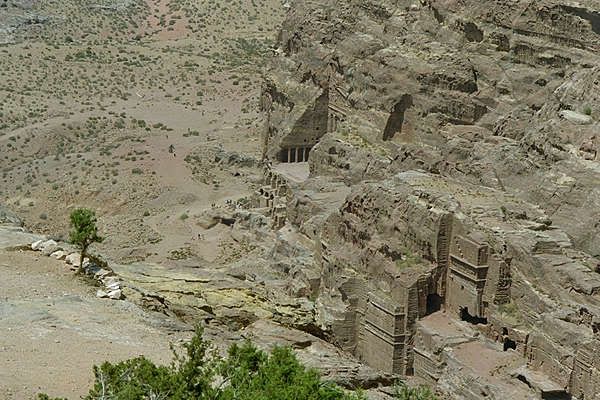
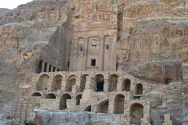
The Royal Tombs
From the theater a stairway leads to the Royal Tombs set into the rock-face of the Jabal Al-Khubtha. These tombs, thought to be those of several Nabataean kings, are certainly amongst the most impressive of the 500 tombs to be found in Petra.
The Urn Tomb was probably constructed around 70 AD. It is preceded by a deep courtyard with colonnades on two sides. High up in the facade there are 3 niches which give on to small burial chambers. Their inaccessibility would have made them relatively safe from tomb robbers.
Inside there is a massive single chamber which may originally have served as a triclinium for funerary banquets, but which was adapted in 446 AD to serve as a Byzantine church, the vaults of which can still be seen below the tombs.
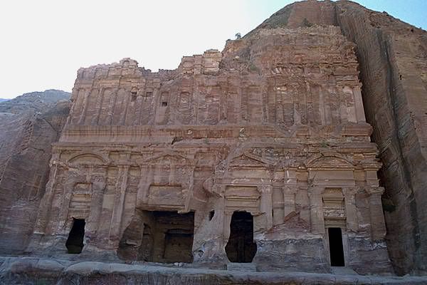
The small Silk Tomb is remarkable for the swirls of different colored rock which make up its facade. Then comes the Corinthian Tomb, which combines various elements of both the Nabataean and the classical architectural styles. Next to it is the broad, 3-storey high Palace Tomb, interesting in that its lower part was cut from the rock, while some of its upper storey was constructed with masonry when the cliff itself proved to be too low.
En route to the Sextus Florentinus Tomb, it is worth noting the large rock-carved cistern which served the city by storing water piped from another huge cistern near the modern Petra Forum hotel, a considerable distance away.
The Sextus Florentinus Tomb, constructed in 130 AD, is one of the few tombs which can be accurately dated. Over the doorway a Latin inscription informs us it was constructed for Sextus, Roman Governor of the Province of Arabia, by his son at his father’s specific request.
It too combines Nabataean and Roman elements, although unfortunately it has been badly eroded. It is interesting that this high-ranking Roman official should have wanted a rock-cut tomb in typically Nabataean style.
The City Center
The first thing to be seen in the city center is the remains of the Nymphaeum, standing in the shade of a tree. Very little is left, but one can imagine from similar monuments elsewhere (the Nymphaeum in Jerash, for example) what this public fountain, with plays of water to delight both the ear and the eye, would have looked like.
It was situated at the confluence of two watercourses, dedicated to the water nymphs and was probably one of the improvements made to the city after the Roman annexation.
A short way beyond the Nymphaeum, the Colonnaded Street begins. Only a short stretch remains of the 6 meter wide paved road, which also seems to have been constructed shortly after the Roman annexation of Petra to replace an earlier Nabataean track.
We should imagine the street as running through an important commercial section of the town, with shady porticoes on each side. The hillsides on both sides of the street would at the time have been covered with buildings serving a variety of purposes. The Colonnaded street led past the Temple of the Winged Lions on the northern bank of the stream, which was crossed at that point by a bridge over the wadi (valley).
The temple is at present under excavation, but it has already been established that it was built around 27 AD and was probably dedicated to the main Nabataean Goddess Al-Uzza, the consort of the Chief God, Dushara.
Some workshops for metal and stone have been found in the complex and these were probably in use later in the 1st century AD when the temple was remodeled. The stone-built temple was totally destroyed in the earthquake of 363 AD.
The Colonnaded Street ends at the Arched Gate, probably built in the 2nd century AD, after the completion of the street, to act as a ceremonial entrance to the sacred precinct (temenos) of the Qasr Al-Bint Temple.
The triple arched gate, which would originally have been closed with huge wooden doors, is of standard Greco-Roman design, but decorated with zoomorphic and geometric motifs showing marked Nabataean features. It is an interesting example of the blend of different cultures.
Once through the Arched Gate one is standing within the sacred precinct of what is today known as the Qasr Al-Bint Temple. This is the only substantial stone-built structure in Petra still standing. Constructed some time around 30 BC – 40 AD, it was built to impress.
Set upon a raised podium, its massive 23 m high walls still dominate the precinct, which also housed an open-air altar. It was the most important temple of the town, dedicated to Dushara, the chief God of the Nabataeans, who later became assimilated with the more familiar Greek god of wine, Dionysus, especially important in Petra due to the custom of funerary banquets where wine would have been drunk.
Inside, the temple is divided into 3 rooms of which the middle room would have served as the holy of holies. This would have had a raised platform bearing a representation of the god Dushara. The typical Nabataean way of representing their deities was by a stone god block (betyle) with a stylized portrayal of the eyes, nose and mouth.
Later, under Greco-Roman influence, they began to depict their gods in statue form. We know from other sources that the interior of Dushara’s temple gleamed with the many gold offerings, which filled it. The temple was damaged in the late 3rd century AD, but, remarkably, the main walls remained standing in spite of several subsequent earthquakes.
Al-Habees
The small but interesting museum is to be found in an unusual Nabataean structure with 5 windows, set into the hillside of Al-Habees. Beyond the museum, on the other side of the hill, is situated the Habees High Place.
This has all the standard facilities of a high place; an altar, benches, a water cistern and approach stairway, but on a small scale, suggesting that it was perhaps a private place of worship.
It commands breathtaking views over the Wadi Sayyagh, one of Petra’s most beautiful wadis, especially in spring and autumn. Some was down the wadi is to be found a stone quarry which the Nabataeans exploited.
On the summit of Al-Habees, is situated a 12th century AD Crusader fortress. Continuing around the hillside one comes across the Columbarium, an intriguing Nabataean tomb fitted with hundreds of shallow niches, the purpose of which remains uncertain.
Shortly after this, and visible from the Qasr Al-Bint below, is the Unfinished Tomb which clearly demonstrates the Nabataeans’ technique of construction, excavating their rock-cut buildings from the top and working downwards.
High Place of Sacrifice
The steep half-hour climb from the theater up to the High Place of Sacrifice on the summit of the Attuf Ridge is well worth the effort. Paths and stairways, which were part of the original Nabataean processional way, lead upwards through spectacular mountain scenery until the long, flat summit is reached.
The most immediately obvious monuments as one reaches the top are the two 7 m high rock obelisks which were made by carving away the surface of the mountain to leave only these 2 protuberances; a formidable undertaking.
The obelisks stand some 30 m apart on an east/west alignment and probably represent the 2 most important Nabataean gods, Dushara and his consort Al-Uzza. Across the gully lies the High Place of Sacrifice, the best preserved of all such sacred places of the ancient world.
This may have been created by the Nabataeans, as the high quality of the stone work would indicate, or it may date back to their predecessors, the Edomites. The rock was leveled to form a shallow courtyard with benches (triclinia) on the north, east and south sides facing the altar platform, on which animal sacrifices were made.
These sacrifices represented the renewal of the close relationship between man and his gods and blood was, of course, a symbol of life. A betyle probably once stood on the top of the altar platform.
A nearby cistern would have provided the water necessary to the ritual. After enjoying the sensational views over the never-ending folds of hills, one may descend to the city center by a different processional way, which follows the Wadi Farasa.
The first monument of interest is the Lion Monument. The lion was associated with the goddess Al-Uzza and this fountain would have provided refreshment for the pilgrims following this processional way up to the High Place.
The water would appear to have spouted from the Lion’s mouth and it was then carried down the hillside through the rock-cut channel visible alongside the stairway.
At the bottom of the stairway one reaches the Garden Temple Complex. On an upper terrace stand a hall and a cistern which once held water brought from the springs 4 km away. This water was subsequently distributed throughout the city center by means of a network of cisterns, channels and pipes.
The portico of the temple on the lower terrace is formed by 2 engaged and 2 round free-standing columns, examples of which are rarely found in Petra. Many small wall-niches lead us on to the Roman Soldier Tomb with its triclinium opposite it.
Although now separate, these 2 monuments would once have been joined by a porticoed courtyard to form a sepulchral complex. In the niches of the tomb’s facade there are fragments of figures in Roman military dress, which give the tomb its name.
These figures, the size of the tomb and the classical style of its architecture would suggest it was built after the Roman annexation of 106 AD for a person of considerable importance.
The funerary banqueting hall (triclinium) opposite is notable as having the only carved interior decoration in Petra, with fluted engaged half-columns. The colors of the natural rock are also amongst the most striking in the city.
Nearby are the Renaissance Tomb and the Broken Pediment Tomb. The path then passes many other tombs and houses set out in streets of different levels before reaching the city center.
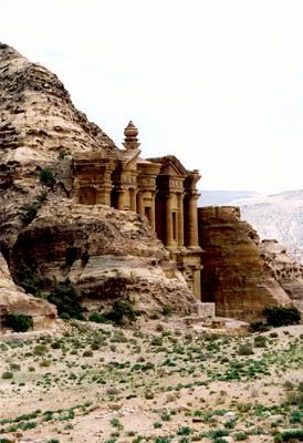
Al-Deir (The Monastery)
The modern name of Al-Deir comes from the fact that the Nabataean structure was perhaps used by Christians in the Byzantine period. However, the processional way, which we follow upwards from the restaurant near the museum, through the Wadi Al-Deir for an hour, is Nabataean.
It is a tiring climb made worthwhile not only by the other monuments to be seen en route, but also by the mountain scenery and splendid views. After a short walk one reaches the Lion Triclinium set in a small side wadi. It is so called because of the 2 badly eroded lions carved either side of the doorway.
Lions, it will be recalled, were associated, in Nabataean sculpture, with the goddess Al-Uzza. The higher one climbs the more impressive the views become until one finally emerges at the Hermitage, chambers excavated in the rock, decorated with many carved crosses.
From this point there is a magnificent view back to the city center and the Royal Tombs. A short climb through the narrow passage brings one out suddenly onto the large open area in front of Al-Deir where no doubt the faithful congregated after completing the processional walk.
Al-Deir itself is cut into the mountainside but not dominated by it. One really needs to see a human figure at its base to appreciate the huge scale of the largest facade in Petra.
The doorway alone is over 8 m high. The temple/tomb is devoid of decoration, but striking in its simplicity and magnitude. It was no doubt an extremely important site of pilgrimage with its carefully orchestrated processional way terminating in the vast open area in front. A short way beyond, one is rewarded by magnificent views from a new perspective in the direction of the Wadi Araba to the west.
Siq Al-Barid or Little Petra
The Siq Al-Barid is located to the north of Petra, only a 10 minute drive away. A classical temple stands guard outside the miniature siq which would appear to have been an important suburb of the city of Petra, situated at the point where several ancient caravan routes met, linking Wadi Araba with Gaza, Egypt and the Mediterranean coast.
The narrow file, only some 350 m long, is crammed with tombs, temples, triclinia, houses, water channels and cisterns, in brief, a “Little Petra”. Of particular note are the remains of painted frescoes on plaster dating from the 1st century AD, which are to be found in one of the biclinia.
Petra Valley, large
Road to Petra, large

map of Petra
Key of the Map
1. The Shiq شق
2. The Khazaneh خزانه
3. Necropolis
4. Roman Amphitheatre
5. The High Place of Sacrifice
6. Tombs
7. Royal Tombs
8. Tomb of Sextius Florentinus
9. Market Place
10. Colonnaded street
11. Temenos Gateway
12. Qasr al-Bint Firaun قصر البنت فرعون
13. Crusader castle
14. Temple of the Winged Lions
15. to el-Deir – The Monastery
16. El-Deir, The Monastery

Nabatean Houses or Tombs?
google search for Little Petra
Petra pics

Road to Petra

Petra Valley

The Shiq, شق – from the air

Cliffs by the shiq ?

Entering the Shiq

Entering the Shiq

The Shiq, شق – from the top

The Shiq, شق – away from the Treasury

The Shiq, شق – water channels at the sides

What Johannes L. Burckhardt found in 1812

The Shiq, شق – the cleft in the rocks through which Petra ‘s Treasury is visible

The Treasury, Khazaneh (or Library), خزانه

The Treasury, Khazaneh (or Library), خزانه

Treasury from above

The Treasury, Khazaneh & opposite end, خزانه
When standing on the Treasury Steps you can look back at the siq and see how high you are above everyone. You can also see how level the plaza area is. This is all an illusion, as the Plaza floor is really several meters below ground level.
The best way to estimate the level of the plaza floor, is to look at the tombs that are on your right as you exit the siq. At this point, most people are looking at the Treasury, and they fail to look right. Right beside them is the ‘top’ of a djinn rock, and just behind it is the ‘top’ of a tomb peeking out of the ground. This tomb has recently been excavated, and now tourists can clamber down some stairs to see inside.
Ground penetrating radar has been conducted and doorways ‘underneath the Treasury’ and a fountain in the middle of the plaza were discovered. The excavations in front of the Treasury have uncovered one of these doors.

excavation in front of the Treasury (Plaza)

el Deir – The Monastery

el Deir – The Monastery

Petra / top of El Deir

Temple of Winged Lions

Temple of Winged Lions

View from Temple of Winged Lions

The Collonaded Street

The West Collonade

The East Collonade
The Great Temple, before and after excavations by Brown University:

The Great Temple site before excavations, 1993

The Great Temple site after excavations, summer 2002

aerial photograph of the Great Temple

Dramatic Column Fall

partial site plan of the great temple

aerial photograph of the Great Temple

aerial photograph of the Great Temple – 1

aerial photograph of the Great Temple – 2

aerial photograph of the Great Temple – 3

Petra View

Petra City Centre for Nabateans

 a petra panorama

The Urn Tomb

The Palace Tomb
lems.brown.edu/vision/extra/SHAPE/
archaeology.org/…/index
archaeology.org/…/nabataeans”
archaeology.org/…/petra
archaeology.org/…/temple
archaeology.org/…/plan
archaeology.org/…/virtual
lems.brown.edu/…/SHAPE/

Outside View of the Great Temple

Inside View of the Great Temple

Reconstruction: new colors

New Trenches
The Great Temple site after excavations, summer 2002
Leigh-Ann Bedal, Ph.D., archaeologist
petragarden/links
petragarden/poolcomple
ACOR: THE AMERICAN CENTER OF ORIENTAL RESEARCH
Boston Univ/ACOR/affiliate programs
Boston Univ/ACOR/cap06
Boston Univ/ACOR/excav04
Boston Univ/ACOR/excav05
Boston Univ/ACOR/excav2000
Boston Univ/ACOR/excav2001
Boston Univ/ACOR/excav2002
Nabateans in Negev


